THE 'Mighty Clutha' forms the heart of one of the world’s most unique waterways. It traverses the dramatic semi-desert landscape of Central Otago, in the South Island of New Zealand, but the most spectacular river gorges, and much more, have been destroyed ... by dams. This is the unofficial story of the Clutha Mata-Au River and its stolen treasures. It is a story steeped in bitterness, shame, destruction, and sadness.

Clyde Dam ~ Building on an Active Fault

1980, May1980, May


1980's early 1980s, early


1980's1980s


1984, 11 September, by David Wethey1984, 11 September, by David Wethey


1985


1985circa


1985circa


1986circa


1986circa


1986, 2nd December 1986, 2nd December


1987


1987


1988, 14th December 1988, 14th December


19881988


1988, Aerial View 1988, Aerial View


1989 1989


1993, 13th February, by Phil Reid 1993, 13th February, by Phil Reid


1993, 19th April, by Phil Reid1993, 19th April, by Phil Reid


1996


Clyde Dam ~ The Shocking Facts

- 1973. The Clutha Valley Development Commission was set up to evaluate potential sites, and after drilling test tunnels in the Cromwell Gorge, advised against interfering with known landslide areas which were pronounced highly unstable.

- 1976. The Clutha Valley Advisory Committee, set up by the National Government, advised against the high dam (Scheme F), preferring the low dam option (Scheme H) which would not flood Cromwell, Lowburn, the Cromwell Gorge Highway, and cause landslide issues.

- 1976. The site for the high dam was chosen by politicians, not geologists.

- 1977 April. Ministry of Works' bulldozers moved onto the site and began work, before a Water Right had been obtained and before an environmental impact report.

- 1977 late. The Government applied for a Water Right, and was granted one for the low dam (Scheme H), because the low dam would be less affected by known landslide issues. However, work continued on the high dam (Scheme F).

- 1979 November. Construction work began on the right abutment above the level of the low dam, without a legal Water Right for a high dam.

- 1980. National Government M.P.,Warren Cooper, a strong Clyde high dam and ‘think big’ proponent, announced that NZ would need six or seven dams the size of the Clyde dam by 1995, contrary to evidence of a looming over supply.

- 1981 July. The Government approved the construction of the high dam despite still not having a legal Water Right, and previous warnings regarding gorge instability.

- 1981. It was realized that there was an over production of electricity and that the dam, especially Scheme F, was not required. Construction continued mainly to keep the work force employed.

- 1981 December. The Government put the Clyde dam project out to tender. Seven tenders were received. The Ministry of Works originally tendered at $156.4 million, later revising this to $117.3 million.

- 1982, April. The Clyde Dam construction contract was awarded to a joint venture of W Williamson & Co of Christchurch and Ed Zublin AG of Stuttgart, West Germany. The winning bid was $102.6 million. Zublins were partnered with Williams Construction of Christchurch as ‘window dressing’ (2.5% of the partnership). The so-called joint venture was plagued with industrial disputes throughout the contract. Their workers also suffered more accidents than workers employed by other contractors on the project.

- 1982. Workers discovered a faultline directly under the dam and spillways. (The River Channel Fault branching from the main Cairnmuir-Dunstan Fault crossing the gorge 3kms above the dam.) Vast amounts of slurry concrete were pumped into tunnels across the fault called “shear pins” to supposedly lock the fault, even though the fault was 12-15kms deep and such “dental concrete” would be instantly broken in a large earthquake.

- 1982. The dam was re-designed with a controversial “slip-joint,” supposedly allowing 2 metres of lateral movement, and 1 metre of vertical movement. Geological evidence showed much greater movements had occured and are possible, up to 9 metres laterally! Even more alarming, one of New Zealand's leading geotechnical scientists, Gerald Lensen, warned that the River Channel Fault was a secondary "tensional fault" (expanding), and therefore the "slip-joint" was NOT designed correctly. Despite compelling evidence supporting Lensen, he was ignored. He resigned in protest and the issue was covered up.

- 1982. The Government obtained a Water Right through the National Water and Soil Conservation Authority, whose chairman, Bill Young, was also a member of the Government and minister in charge of the project.

- 1982. Landowners appealled to the High Court, citing bias and that the Government did not have a legal Water Right for the Clyde dam, and they won their case.

- 1982. The National Government, under Prime Minister Robert Muldoon, enacted the Clutha Development (Clyde Dam) Empowering Act 1982, controversially over-throwing the High Court decision and a subsequent Planning Tribunal decision against the Government (Annan v National Water and Soil Conservation Authority and Minister of Energy, Gilmore v National Water and Soil Conservation Authority and Minister of Energy), suspending the legal/lawful rights of the individual enshrined in Westminster law, and shocking New Zealanders.

- 1986. Artesian water was discovered in what was previously considered to be dry landslides in the Cromwell Gorge, signalling serious issues with reservoir safety.

- 1986-7. Construction peaked with around 1000 workers on site.

- 1987. New Zealand Electricity Department (NZED) becomes Electricity Corporation of New Zealand (ECNZ / ElectroCorp) - a state-owned enterprise.

- 1987. WorksCorp sold the ‘dam’ to ElectroCorp (ECNZ).

- 1989. April. An intense investigation began into landslide issues, involving up to 40 geologists, revealing large numbers of highly permeable loess underlying large areas of broken rock slides, throughout the gorge.

- 1989. It was realized that the 1982 re-design had omitted one of the two sluice gates. A work-around was designed costing $2 million, reducing the dams generating capacity by nearly a third from 612 MW to 432 MW.

- 1989. ElectroCorp (ECNZ) admitted that they might have to ‘mothball’ the dam because it was fast becoming cost ineffective.

- 1990 March. Serious gorge stabilisation issues were admitted, and it was announced that the project could not be commissioned without another $337 million being spent on landslide mitigation to reduce, but not remove the risks.

- 1990 May. Warren Cooper M.P. denounced recommendations from an international review team of geologists, claiming they were creating “the biggest man-made work scheme on record.” Critics noted that he had been one of the project's leading proponents.

- 1992. Commissioned 1992 (began producing some power).

- 1993. Completed.

- 1994, 23 April. Officially opened.


PM Robert Muldoon's 'Rob's Mob'Prime Minister Robert Muldoon and 'Rob's Mob'
(Muldoon 2nd from left, Warren Cooper 2nd from right)


- 1996. ElectroCorp (ECNZ) was split into two state-owned enterprises - ECNZ and Contact Energy, the latter controlling the Clyde and Roxburgh dams.

- 1999. Contact Energy was privatized, with 40% purchased by Edison Mission Energy (EME) which subsequently increased its shareholding to 51%.

- 2004. EME onsold its majority shareholding to Origin Energy of Australia, which thereby obtained a controlling interest in one of NZ's largest and most expensive infrastructure assets, originally paid for by NZ taxpayers.

- 2009, May 2. Clyde high dam: “The single most monstrous environmental sin over the last 30 years.” - Michael Cullen, Radio NZ, speaking of his biggest regrets after retiring from the Labour Party. Labour inherited the dam fiasco from the Muldoon government in a snap election in July 1984, called by Muldoon after he had lost the confidence of parliament and New Zealanders. Unfortunately, Labour persevered with the ever-more problematic Clyde dam, and after National became the government in 1990, the 'monstrous environmental sin' was completed.


Clyde Dam Statistics

- Site chosen: 1976
- Construction: 1977-1993
- Commissioned: 1992-1993
- Type of Dam: Concrete gravity dam (largest in NZ)
- Dam Height: 102 metres
- Net Head of Water: 60 metres
- Width at Base: 70 metres
- Width at Top: 10 metres
- Length at Top: 490 metres
- Penstocks: 4 (plus 2 encased in concrete)
- Spillways: 4 with radial arm gates
- Sluices: 1 low level with radial arm gate
- Planned Capacity: 612MW
- Installed Capacity: 432MW
- Lost Capacity: 180MW (due to re-design error in 1982)
- Turbines: 4x Francis fixed-blade turbines connected to 108MW salient pole generators
- Total Concrete Poured: Approx. one million cubic metres
- Steel used in Penstocks: Approx. 1,350 tonnes
- Total Steel used: Unknown
- Weight of Dam: Approx. 3 million tonnes
- Annual Energy Generated: Averages 2,100GWh
- Reservoir Size: 26.4 square kilometres
- Reservoir Fill Time: 18 months (reached full operating level September 1993)
- Major Landslide Zones: 14 extending along the gorge from Cromwell to the dam
- Stabilisation Tunnels: 18kms of tunnels dug during gorge stabilization work
- Measuring and Monitoring Instruments: 6,500 originally installed
- Drainage Mitigation: 140 kilometres of drilling for drainage
- Landslide Buttressing: 5 million cubic metres of rock used in buttressing work
- Land Flooded: 2,300 hectares
- Operational Range of Reservoir: Between 193.5 to 194.5 metres above sea level
- Reservoir Storage Capacity: Described as "Not much"


Stabilisation Cost: $936 million (2005 value)

TOTAL Project Cost: $1.4 to 2 Billion (exact cost is unavailable or unknown)


Operation: The reservoir does not have much storage capacity, so the Clyde dam operates mainly on a ‘run of the river’ basis, with the average flow past the dam reflecting the natural flow of the Clutha and Kawarau Rivers. The expected variation of the reservoir is about 50cms. When inflows are low, storage at Lake Hawea is drawn down to compensate. The high dam option (Scheme F) was built supposedly to maximise generation and cost-efficiency. But the low dam option (Scheme H) could also have operated on a ‘run of the river’ basis with only 2% less output, avoiding the loss of old Cromwell, Lowburn, and a massive cost overrun. The low dam (Scheme H) would also have incurred fewer landslide issues, retaining 16kms of the original 21 km highway through the Cromwell Gorge. However, both options were inherently flawed, and were not defensible when measured against the geo-technical risks, landslide mitigation costs, long-term reservoir sedimentation issues and costs - including eventual decommissioning, loss of ecosystem integrity, and heritage and human costs.


A Brief History

Long before the Clutha Mata-Au had a name, before the Moa-hunters, and before the gold-rush, a mighty earthquake ripped through the Cromwell and Kawarau Gorges, providing new outfalls for Lakes Wanaka and Wakatipu. The Upper Clutha Mata-Au and the Kawarau Rivers were born, and the confluence of these powerful rivers cut the famous 'Cromwell Junction.'

Maori explorers, Ngai Tahu and Kai Tahu ki Otago, followed the Mata-Au inland, through a wild and untouched land, hundreds of years before Abel Tasman sighted New Zealand. Their seasonal explorations yielded prized argillite stone, fibres from flax, from the fronds of the cabbage tree and from the leaves of the Celmisia mountain daisy. They also came for foods such as Moa, eel, duck and pigeon. In time, they established campsites and seasonal inland settlements.

Nathaniel Chalmers, a young twenty-three old in search of good sheep country, was the first European to ascend the river in 1853. He was guided by two old Maoris, Chief Reko and Kaikoura, paying them in advance with a three-legged iron pot. The old Maoris were veterans of the river route, such that when Nathaniel Chalmers fell ill, they simply constructed a mokihi, or koradi (flax flower-stalk) raft, and guided him down the river, fearlessly running major rapids in the Cromwell and Roxburgh Gorges.

Perched above 'the meeting of the waters' grew the 1860's gold-rush town of Cromwell, overlooking the spectacular Cromwell Gap Rapid. When the gold workings declined, farming and fruit-growing became the town's mainstay. Little changed until the 1980's, when the then National government's 'Think Big' agenda brought massive upheaval as plans for New Zealand's largest concrete gravity dam moved ahead, despite widespread protest.

The exploitation of the Clutha for maximum power at any cost, was driven by departmental and political ambitions that would prove too insidious to be checked, even by the courts. The inexorable weight of the NZED (New Zealand Electricity Department) and the MOW (Ministry of Works), coupled with a secret deal made by naive government ministers providing COMALCO (Rio Tinto) with cheap electricity, set the agenda and fuelled the official lust for power.

Threatened landowners went to the High Court, winning their case against the Government. But the democratic provisions of the New Zealand legal system were over-ruled by the Government, lead by Prime Minister Robert Muldoon, and the dam went ahead, in what can only be described as one of the most shameful chapters in the history of New Zealand.

During construction of the dam, the bed-rock was found to be microfractured because of a major earthquake faultline. Vast amounts of slurry concrete were pumped into the rock to stop water leaks. Subsequent landslide stabilization problems halted the project while experts debated safety issues. Eventually, the Government decided to proceed, and 18kms of drainage tunnels, with 24-hour pumping and monitoring stations, were embedded in the 'slide zones' of the gorge. A massive cost blow-out brought the total cost to nearly $2 billion, amidst continuing controversy over the dam's safety, viability and necessity.

In 1992, the rushing waters of the Cromwell Gorge were silenced as the reservoir behind the Clyde Dam began rising. Filled in three stages between 1992-93, the reservoir gradually flooded the spectacular Cromwell Gorge, the historic heart of Cromwell, many orchards and homes, the settlement of Lowburn and the surrounding fertile farmland - a total of 2300 hectares of the best orchard and farmland in Central Otago.

The lifespan of the dam is estimated to be 80 years, but opponents doubt that it will survive that long, given the ongoing instability of the Cromwell Gorge, the risks posed by earthquakes and landslides, and the speed of reservoir sedimentation.

Clyde Dam Burst ~ What Would Really Happen?

It is often said that if the Clyde dam ruptured, the resulting torrent would bypass the town of Clyde allowing sufficient time for the residents to leave before the waters arrived. This is an official myth.

What would cause a dam burst?

Earthquake:
Obviously, a large quake along the Alpine Fault could wrench the Cairnmuir-Dunstan faultline laterally a few metres or even several metres. This fault is some 3 kilometres above the dam. Gerald Lensen, one of New Zealand's leading geotechnical scientists when the dam was being built, maintained that this fault movement would tend to open up the secondary River Channel Fault which branches off the main fault and runs directly under the dam. This opening movement is described as “tensional," and alarmingly the “slip-joint” is designed for lateral movement, not tensional. Regardless of this argument, a large earthquake has the potential to rupture the dam. Earthquakes are the main cause of concrete dam failures.

Earthquake Generated Wave:
Just as earthquakes cause ocean tsunamis, they can also cause wave events on inland waters. The Alpine Fault is moving laterally while one side tilts upward and the other side is subducted. The Clyde “slip-joint” is designed to cope with a maximum of 1 metre of vertical movement, and two metres of lateral movement. If such a 1 metre vertical movement occurred in a strong earthquake event, the bed of the reservoir on the upward side of the fault would be abruptly lifted. It has been calculated that a 1 metre lift would move 23 million cubic metres of water, generating a swift and destructive wave. It would carry debris from the sides of the gorge that when combined with the force of the wave, could do catastrophic damage to the dam. Such an earthquake-induced wave would at least overtop the dam with devastating consequences.

Landslide Generated Wave:
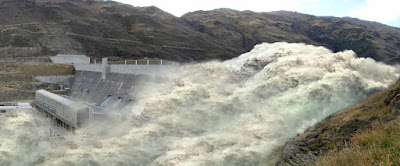
Any large landslide in the Cromwell Gorge could cause a wave capable of overtopping the dam. The likely cause of such a landslide is heavy rain or an earthquake. The wave would travel in both directions, towards the dam, and towards Cromwell, and could be powerful enough to do considerable damage. For example, if the massive Nine Mile slide collapsed into the reservoir it could easily block the gorge creating a fast-moving and devastating wave. It is possible that the dam could survive a wave strike reasonably intact, though the Clyde dam is not the stronger arch design. Even if the dam wasn't breached, the overtopping wave could still cause a major disaster. The wave could be 100 metres high and such a wave would travel at around 160-240 kilometres per hour, devastating a large area below the dam.

Earthquake, Landslide, Wave:
In the event of a large earthquake, any one or all three of the above scenarios could occur. For example, an earthquake could rupture the dam without causing a significant wave, or both a rupture and a wave could occur. Also, an earthquake might do minimal damage to the dam, but cause a large landslide generating a powerful overtopping wave, which might rupture the dam or flow over it, causing a disaster either way. Worst of all, is the combination of an earthquake rupturing the dam, followed by a wave induced by the same earthquake, and also landslides caused by that earthquake, in turn causing more waves.

So what would really happen in an overtopping or dam burst event?

It is ironic that the “slip-joint,” hailed as an innovation to mitigate earthquake damage, could itself become a weakness if it failed to work as designed. If the wedge pulled apart during an earthquake or was damaged sufficiently to cause a breach, the resulting leak would be under immense pressure, and what would happen then is open to speculation. If the flow increased, how that could be stopped from rapidly deteriorating into a catastrophic dam burst is unknown.

The dam was built in two “halves” either side of the 2 metre wide join. The left side (facing), furthest from Clyde, was built by the Ministry of Works, while the right side (facing), closest to Clyde, was built by Zublin-Williamson. During construction the German contractors (98% of the so-called Zublin-Williamson “joint venture”) were found to be rushing the preparation of the concrete batches, pouring them so fast that “honeycombing” was occurring. The supervising contractor, the Ministry of Works, repeatedly asked for sub-standard poured blocks to be drilled out and re-poured. This has led to a widely held view that the right side of the dam has weaker block work than the left side.

In January of 1990, Electrocorp released a report of their findings following a computer modelling exercise using a US software programme called ‘Dambrk.’ The software was developed to determine the extent of damage in the event of a dam being overtopped or breached. The results depended entirely on the data input, and in this case Electrocorp entered the scenario of a 20% outflow of the reservoir, said to be the equivalent of a maximum flood. They expected this water to be released through the three “blocks” nearest the right side abutment, presumably the weakest part of the dam.

Whether a rupture occurred through the “slip-joint” or on the right side, in both parts or elsewhere, the sudden release of water would be phenomenal. The water would blast through the dam at 160-240 km per hour, scouring everything as it went, carrying ever more debris as it pulverised everything in its path. Rocks and boulders, trees and buildings, cars and people, would all be swept away in the disaster.


Impression using Photoshop of a failure in the Clyde dam 'slip-joint' caused by an earthquakeImpression using Photoshop of a failure in the Clyde dam "slip-joint" caused by an earthquake


An overtopping landslide wave would have less pressure but would still travel almost as fast as water rupturing through the dam. If the dam survived the wave strike, the wave pouring over the dam could still scour down the block work or scour into an abutment. The water would blast through any weakness. Such a wave would not necessarily travel directly down the gorge, but could wash from side to side, and therefore could strike the dam initially on either side.


Impression using Photoshop of a breach in the right facing blocks of the Clyde dam caused by a landslide waveImpression using Photoshop of a breach in the right facing blocks of the Clyde dam caused by a landslide wave


According to Electrocorp, however, the waters issuing from an overtopping or dam burst event would take a full 6 minutes to reach Clyde, even though this is longer than it takes for the river to cover the same distance in normal flow. They said that the Clyde Bridge would be washed away, and that a “gentle swell” would go down the river and reach Alexandra in 1.5 hours, where the river would be some 12.5 metres above normal at the Alexandra Bridge, supposedly equivalent to a 1000 year flood. The report said that there would be some flooding in Alexandra, and more serious flooding in the Manuherikia area, before the water would flow down the Roxburgh Gorge.

Electrocorp’s version of events was unbelievably benign. Strangely, they considered their ‘Dambrk’ report to be insufficient for the purpose of Civil Defence planning. This alone, suggests that the report was too unreliable, too deficient in realistic input data, too fictional, to be taken seriously. In short, they belittled what is a gravely serious issue, trying to make it palatable to the public.

What would happen to the Roxburgh Dam?

Remember, all that water has to go somewhere, and a wall of water and debris travelling at 160-240 kms per hour doesn’t give much warning, or allow much preparation for the coming disaster. The main form of mitigation at the Roxburgh dam, Electrocorp said, would be lowering the level of the reservoir. The Roxburgh dam, they said, if it was discharging and generating to capacity, could lower the Roxburgh reservoir 45cms in 6 hours.

It is difficult to imagine that this would be enough to contain the water surging down the gorge. The narrowness of the upper gorge would certainly restrict but also speed up the flow, and at the lower end of the gorge where it turns in an ‘S’ shape and opens out around McKenzie’s Beach, the wave would diminish, but the dam would still be faced with more water than it could safely spill. If the initial surge left the dam intact, the rising reservoir would soon overtop the dam and there would be no way to prevent widespread, catastrophic flooding, and probably a major dam failure.

We are supposing, of course, that if the cause of the devastation at the Clyde dam was an earthquake, that the Roxburgh dam was spared, and did not also breach or receive an overtopping wave at the same time. But either way, the Roxburgh dam is unlikely to survive.

Millions of tonnes of silt would be drawn down and spread out over the Teviot Valley. The surge of water, silt and debris would be partially restricted at Dumbarton Rock, but would nevertheless continue towards the sea, destroying and burying everything in its path. At Balclutha, the speed of the flood would be slowing and the level of silt and debris would be reduced to perhaps a few metres, and yet the waters would still inundate the town within minutes, flowing out across Inch Clutha into the Pacific.

Is there a dam disaster like this on record?

The Cromwell Gorge has been compared to a valley in northern Italy, where a dam was completed on a tributary of the Piave River in 1961. The 262 metre high Vajont arch dam was regarded as an engineering triumph. The people living below the dam were assured that the dam was safe. The sides of the gorge above the dam became unstable when the reservoir was partly filled. The reservoir was repeatedly raised and lowered as the landslide areas were monitored. Engineers and officials were reluctant to admit there was a serious threat to the dam.

On October 9, 1963, at approximately 10.35pm, heavy rain caused a 260 million cubic metre landslide into the reservoir, moving at up to 110 kms per hour. The wave that overtopped the dam was 100 metres high. It reportedly advanced down the valley with incredible speed, preceded by an atmospheric shock-wave. It soon engulfed the towns of Longarone, Pirago, Rivalta, Villanova and Faè, destroying everything in its path, killing 1,450 people. The torrent then swept into smaller villages in the territory of Ert e Casso and into the village of Codissago.

Almost 2,000 people (some sources report 1,909) perished in the Vajont dam disaster. The devastated region was described afterwards as a “mud-covered coffin.” Remarkably, only part of the dam, the top of the right side, was damaged, demonstrating that arch dams provide excellent resistance to wave events, albeit a disaster can still occur. It was later shown that geological investigations had been deficient.


Aftermath of the Vajont dam disasterAftermath of the Vajont dam disaster


It is sobering to realise that such a deadly disaster could occur as the result of an overtopping event. Surely, a dam breach in a non-arch dam would prove even more devastating because a much greater volume of reservoir water would pass through such a ruined dam.

Money and pride first, safety last?

When it comes to admitting the possible extent of the devastation following a dam disaster at Clyde or Roxburgh, there is a noticeable paucity of official information. When the 1999 flood caused serious damage to Alexandra, because of the silted up river bed at the top end of the Roxburgh reservoir, a hue and cry went out to Contact Energy, the dam owners, to fix the problem. Reluctantly, they offered up limited compensation and some remedial flood protection work. They readily exploit the river, but when their activities cause damage, they are difficult to hold to account. This is indicative of a “head in the sand” approach to dam safety issues (perhaps that should be “head in the silt”). Profit drives any business, and dams are built and managed with a degree of conquering arrogance that never really understands that rivers, and tectonic plates, always have the last say.

The Clyde dam is a monument to engineers and politicians. Few among them would admit that they have built a potential disaster. That pill is too bitter to swallow. But the landslides in the Cromwell Gorge are still feeling the impetus of gravity. The rain still falls, sometimes in thunderstorms. Earthquakes still happen, and the “big one” along the Alpine Fault is overdue. When the Earth or the sky rumbles, let the dam builders explain how safe their dams are, and ask yourself ~ why should they be able to risk your town, or your life?

An independent review into the safety of the Clyde and Roxburgh dams is urgently needed. Grave mistakes have been made, and it’s time to face up to the potential consequences of dam failures on the Clutha. Of course, it usually takes a tragedy to kick start such a process.

If you are standing in the main street of Clyde when a wave overtops the dam, don’t wait 6 minutes for it to “gently” arrive. You will probably have a few seconds …


Cromwell Junction ~ Views

Cromwell Junction 1856, by John Buchanan 1856, by John Buchanan


Cromwell Junction 1863, by John Buchanan1863, by John Buchanan


Cromwell Junction 1866, New 'Lattice Bridge'circa 1866, New 'Lattice Bridge'


Cromwell Junction 1873-80, by Herbert Deveril1873-80, by Herbert Deveril


Cromwell Junction 1926, by Albert Percy Godber1926, by Albert Percy Godber


Cromwell Junction circa 1940's Postcard circa 1940s' Postcard


Cromwell Junction circa 1940's Postcard circa 1940s' Postcard


1948 Centennial Stamp1948 Centennial Stamp


Cromwell Junction circa 1980'scirca 1970s


circa mid-1980s


Cromwell Junction circa 1970'scirca mid-1980s, by R.W. Kilgour


Cromwell Junction circa 1980's, Aerial Viewcirca mid-1980s, Aerial View


Destruction of the Cromwell Junction

Cromwell Junction before the Clyde damCromwell Junction before the Clyde dam


Cromwell Junction 1989Cromwell Junction 1989


Cromwell Junction 1993 Cromwell Junction 1993


Cromwell Junction after the Clyde damCromwell Junction after the Clyde dam


The confluence of the Clutha and Kawarau Rivers at the entrance of the Cromwell Gorge has always been at the heart of Cromwell's identity. In fact, the settlement was originally called 'The Junction.' Even when the name 'Cromwell' was adopted in 1866, the town was often referred to as the 'Cromwell Junction' or sometimes 'the meeting of the waters.' Here, the clear turquoise waters of the Upper Clutha, mixed reluctantly with the silt-laden waters of the Kawarau.

This remarkable sight, viewed from high above, was often painted and photographed, and appeared on a New Zealand stamp. The once famous Cromwell Junction was perhaps the most spectacular river confluence in the world.

Perched high above the ‘Junction’ on a rock promontory, the historic gold-rush town of Cromwell boasted one of the most picturesques locations imaginable. Cromwell's historic main street was mostly intact with numerous gold-rush era buildings, and at the end of the street, the massive 1866 bridge crossed high above the famous Cromwell 'Gap' Rapid. A Chinese gold-mining settlement was virtually untouched on the encarpement of the Kawarau 'arm,' and further up the Kawarau was the most highly rated whitewater rapid in the world - Sargood's. Cromwell was poised to become a tourism icon, a historic town unlike any other, and a watersports Mecca.

However, 'think big' obliterated the 'Junction.' The dam builders were ruthless, not only flooding, but systematically destroying the 'Junction' as if to physically remove it from the hearts of those who loved it. When the Clyde dam is eventually decommissioned (it has a design life of about 80 years), the waters will gradually be lowered in stages and the 'Junction' will be revealed, but it will never be quite the same after restoration, which will be a long and difficult process. Large dam decommissioning and river restoration projects take about 10-15 years to complete. Worldwide, although only a few large dams have been decommissioned to date, such projects will become more common as an increasing number of ageing dams face removal. Typically, no provision is made for the cost of 'undoing the damage.'  Decommissioning costs for large dams range from 35-150% in proportion to the cost of a new dam. The obvious question is, who will pay?

Landslides ~ Gravity Always Wins

In 1973, a Clutha Valley Development Commission was set up to evaluate potential hydro-electric dam sites along the Clutha River. Test drilling in the Cromwell Gorge confirmed what local people already knew, that the gorge was highly unstable. A few years later in 1976, the National Government convened a Clutha Valley Advisory Committee to assess all the available information and to make a decision regarding proposals for high and low dams.

The Advisory Committee acknowledged that there was a serious instability issue, and finally voted to recommend the low dam option (Scheme H), however three members of the Committee who knew the gorge well, voted against any dam at all, referring to the prospect of inevitable landslide issues.

Surprisingly, gorge instability was given little consideration when the high dam option (Scheme F) was chosen. But in 1982 dam workers discovered a faultline directly under the dam and spillways. Investigations revealed that this was a River Channel Fault branching from the main Cairnmuir-Dunstan Fault crossing the gorge some 3kms above the dam. Vast amounts of slurry concrete were pumped into tunnels across the fault called “shear pins” to supposedly lock the fault, even though the fault was 12-15kms deep and such “dental concrete” would be instantly broken in a large earthquake.

It was acknowledged that a fault directly through the dam and spillways warranted some attention. The dam was redesigned around the fault and the "slip-joint" was invented to sit over the fault. The dam was literally built in two "halves."

As time passed, more problems came to light. In April 1989, an intense investigation began into landslide issues, involving an international team of up to 40 geologists. This investigation revealed large numbers of highly permeable loess underlying large areas of broken rock slides, throughout the gorge. It was feared that when the reservoir was raised, the water would permeate through the toes of the slides, triggering landslides into the reservoir, creating waves that could overtop the dam.

Fourteen major slide zones were identified in the Cromwell Gorge, including one beside the dam itself - the Clyde landslide. Another three major slide zones were discovered in the affected part of the Kawarau Gorge, including the Ripponvale landslide. Water was the primary issue, since water entering the permeable loess (fine layers beneath the slides) from above or below, would literally lubricate them, resulting in accelerated movement or a sudden failure.


Cromwell Gorge Landslide Areas Cromwell Gorge Landslide Areas


The rate of landslide "creep" was difficult to measure since there was insufficient data available upon which to accurately assess the amount of movement in each slide. The new road cutting above the old road had actually increased the rate of movement in many slides by removing material from the toes of the slides. Geologists soon installed instruments and estimated movements ranging from millimetres to centimetres per week or per year, subject to rain/water and earthquake induced movement. The massive Nile Mile slide, seven kilometres long and 200 metres high, was moving several centimetres per week. The extent of the problem was vast. The international team of geologists described many of the slides as "potentially catastrophic" and "very dangerous." The cost of the proposed stabilisation measures kept going up, but the work began.

Major remedial work was undertaken at nine of the seventeen landslide zones, involving toe buttressing, pumped drainage, gravity drainage, capping to reduce infiltration from above, and the drilling of "grout curtains" to reduce leakage from the reservoir into the toe area of slides.


Cromwell Gorge Landslide Stabilisation Measures Cromwell Gorge Landslide Stabilisation Measures


Eighteen drainage tunnels were drilled into the sides of the gorge. From these "drilling stubs" drainage holes were drilled further into the slides. A total of 140kms of drilling was undertaken for drainage, and 6,500 measuring and monitoring instruments were installed.

To install "grout curtains," holes were drilled at regular intervals to varying depths into which concrete and water was pumped under pressure. Many of these holes collapsed during drilling because of the loose nature of the material, and each time this happened, the drillers pumped in concrete and water, and later re-drilled it. This was an extraordinarily time-consuming and expensive exercise.

Buttressing rock was also placed across the base of some slides to provide some frictional resistance. A total of 5 million cubic metres of rock was used in buttressing work.

The Cairnmuir landslide posed a significant challenge, since the upper material was particularly loose and permeable, and riddled with rabbit holes. A network of drainage tunnels combined with buttressing at the toe of the slide failed to stop it moving, so it was eventually decided to pave and terrace the top of the slide to seal out water, creating a bizarre amphitheatre. The rate of movement slowed, but the additional weight means that any increased infiltration could result in an even greater failure.


Cairnmuir Landslide during stabilisation work Cairnmuir Landslide during stabilisation work


Cairnmuir Landslide ~ Aerial View Cairnmuir Landslide ~ Aerial View


In the end, the investigation and stabilisation work cost a staggering $936 million. Work on the Nine-Mile landslide alone, reportedly cost $60 million.

Landslide "creep" has been reduced, but monitoring indicates the continuing potential for slide zone failure. Monitoring has shown that movement of a known "active" part of the Brewery Creek landslide is triggered when the water level exceeds a critical threshold in a key piezometer (instrument for measuring hydraulic pressure). Records also show that movement of part of the Ripponvale landslide increases following prolonged rainfall, and that it is highly sensitive. Data indicates that the rate of movement of the Ripponvale landslide increases when the cumulative rainfall during a period of 3 to 4 months exceeds a total of about 300 mm. It has been suggested, alarmingly, that a failure of the seven kilometre long Nile Mile landslide could form a debris dam causing a catastrophic wave event, followed by widespread inundation in the Cromwell area.

Despite all that has been done, and the mind-boggling cost, major landslide zones in the Cromwell Gorge are still prone to failure under the impetus of heavy rain events, and of course earthquakes. The landslide risk has not been removed, and no one knows when the next major landslide will occur.


Lowburn ~ Sold Down The Reservoir

Lowburn residents outside the Welcome Home Hotel, 1978Lowburn residents outside the Welcome Home Hotel, 1978


The Lowburn community began as a prominent ferry landing during the early years of Central Otago's settlement, when travellers moved between the goldmining reefs of Bendigo and the township of Cromwell. A ferry or punt began operating on the Clutha River at Lowburn from about 1873, and the crossing, with its tree-lined approaches and picturesque setting became not only an important link between Cromwell and the lakes at Wanaka and Queenstown, but also a popular tourist excursion. A bridge was built in 1938 replacing the punt, and the occasion was celebrated by a banquet at the Lowburn Ferry Hotel followed by a dance at the Lowburn Hall.

So important was the ferry, that even after the bridge was built, the community was still referred to as Lowburn Ferry. Beyond the settlement at the crossing, the valley extending up the river contained some of the most productive farmland in Central Otago, and some of the most scenic. Orchards also filled the smaller valley behind the hotel, where an ideal micro-climate suited the stonefruit grown there.


Clutha River, Lowburn area before the Clyde damClutha River, Lowburn, before the Clyde dam


The inner floodplain of the Clutha River, naturally braided as it approached Deadman's Point, had been extensively dredged above and below the crossing, and this unique section of the river had become a maze of river channels and swimming-holes, lined with mature willows, sometimes called the 'Hundred Islands'. Not surprisingly, the area had become popular with campers during high summer. Small tracks weaved among the old tailings, arriving at campsites and swimming-holes.


Hundred Islands'Hundred Islands' above the Lowburn crossing


Rumours of further hydro-electric development that might inundate more gorges and valleys had circulated since the completion of the Roxburgh dam in 1956, and these rumours surfaced with a vengeance in the 1970's. Uncertainty over the future of the Lowburn area became a topical subject in the Lowburn pub as locals contemplated the possible demise of their community.

In the lead up to the New Zealand elections in 1975, one aspiring candidate was Warren Cooper. When questioned at the Lowburn pub by Shorty Sutherland, a retired gold-miner who lived across the road, Mr Cooper promised not to flood Lowburn and the pub. Mr Cooper said: "If you want water in your whiskey, vote Labour."


Shorty Sutherland, and Pythagoras the cat, Lowburn. 'Someone should have shot him (Muldoon) years ago. Me, I wouldn't waste my ammunition. You can tell him that from me.'Shorty Sutherland, and Pythagoras the cat, Lowburn. 'Someone should have shot him (Muldoon) years ago. Me, I wouldn't waste my ammunition. You can tell him that from me.' He was assured by MP Warren Cooper that Lowburn would not be flooded.


In 1977, Warren Cooper MP, strode onto the recently constructed Clyde dam lookout, beyond which work had begun on the dam that would eventually flood the Cromwell Gorge, part of Cromwell and much of the Lowburn area including five orchards and the Lowburn pub - where he had made his earlier promise not to flood the hotel and the surrounding area. He had come to address a protest group called "Clutha Rescue," who had set up camp at the lookout. Mr Cooper asked: "Why can't you support me over the construction of this dam?"

The building of the dam was opposed by five landowners at Lowburn and two in the Cromwell Gorge. They took their case against the Government to the High Court in Wellington, who ruled in their favour, determining that there was no end user for the power at Clyde and that the applicant had no water right.

But Prime Minister Robert Muldoon rallied his supporters. In the end, legislation was passed with the help of the two Social Credit MP's. The Clutha Development (Clyde Dam) Empowering Act was enacted on the 30th of September 1982. All legal avenues for legitimate objection had been removed.


Lowburn pub sign in the 1980's ~ 'In 198? this hospitable place could be 20 metres beneath the new Lake Dunstan.' This sign of a man having a beer through a snorkel was placed on Lowburn's Welcome Home Hotel in the 1980's. It voiced the stoic despair of a community facing inundation if, and when, the Clyde dam reservoir would be pronounced safe enough to fill.


The Lowburn community had been cast aside, sold down the reservoir, lock stock and beer barrel. Outside the pub, a sign appeared showing a man drinking a beer through a snorkel. In 1988, the bulldozers arrived to demolish the hotel and 'reshape' the valley. The Welcome Home Hotel, the Motor Camp, the houses along the main street, five orchards, the concrete arch bridge across the Clutha, the "hundred islands" with numerous popular campsites and swimming-holes, and some of the best farmland in the region, all disappeared into the pages of a bitter history.


Lowburn Valley after the Clyde damLowburn area after the Clyde dam


Clyde Dam ~ The Slip-Joint Problem

The Clyde dam "slip-joint" has been hailed as a design and engineering triumph. When dam workers discovered a faultline during foundation work in 1982, little was known about the geotechnical characteristics of the site, and although instability was a known issue in the Cromwell Gorge, the underlying reasons for this had not been investigated in any detail.

So what exactly did the dam workers discover?

In this case, the fault was essentially a band of pulverised schist rock, running along the bed of the gorge on the right side of the dam (facing). This fine material, between solid rock structures, indicated that substantial movement had occurred on either side.

Some remarkable decisions followed the discovery of the fault, before the full extent of the problem was known. Vast amounts of slurry concrete were pumped into "shear-pin" tunnels drilled across the fault. This grouting was intended to lock the fault blocks together under the dam foundations.

The River Channel Fault, however, is 12-15 kms deep, and critics maintained that the grouting would simply be torn apart, along with the surrounding rock, in a large earthquake. The grouting was described as "dental concrete."

The dam was rather hastily re-designed in 1982, so much so that a sluice channel was omitted from the plans, and the dam workers, of course, built the dam without the missing sluice gate. A later "work around" solution cost $2 million and reduced the dam's generating capacity from 612MW to 432MW.

The most important feature of the re-design was the "slip-joint." It was not based on a known and tested design. However, it was innovative and was regarded as "state-of-the-art" geotechnical engineering. As such, the designers won an award.


Location of the Clyde dam join and Location of the Clyde dam join and "slip-joint"


The design premise of the "slip-joint" is that the fault will "slip" sideways and perhaps uplift in a large earthquake. To mitigate such movement, the dam was built in two "halves" with a two metre gap between them, sealed on the reservoir side by a vertical concrete "wedge plug" that is held in place by water pressure. The theory is that this "wedge plug" will allow up to 2 metres of lateral and 1 metre of vertical movement, while the water pressure holds it in place against the dam.


Inside the Clyde dam looking toward the Inside the Clyde dam join looking toward the "slip-joint" wedge


Looking up the wedge Looking up the wedge


Looking down the wedge Looking down the wedge


An obvious issue arises if the movement exceeds the design capability. Research has revealed that both small and large movements have occurred on the site, and have been as much as 9 metres laterally. The Alpine Fault has not had a major rupture since 1770, and one is expected within the next 1-20 years in the order of magnitude 8+. Such an event has the potential to result in more than 2 metres of lateral movement through the dam. This shearing action would render the "slip-joint" ineffective, and water under enormous pressure would be forced through the join, perhaps precipitating a catastrophic failure.

But there is another issue that raises a serious question, to say the least. Was the "slip-joint" design premise correct?

The River Channel Fault is described as a "Secondary Fault" because it branches from the main Dunstan-Cairnmuir Fault that dissects the gorge some 3 kms above the dam. Gerald Lensen, one of New Zealand's leading geotechnical scientists involved in active fault research and mitigation planning, maintained that the River Channel Fault was tensional (apart rather than lateral), and therefore the "slip-joint" was NOT designed correctly.

Lensen's analysis becomes clear when the geotechnical structure is examined. The "slip" movement will naturally occur in the main Dunstan-Cairnmuir Fault, and since the secondary River Channel Fault is at right angles to this, it will pull apart as the main fault moves laterally. This opening process had contributed to the formation of the Cromwell Gorge.

The extent of this tensional movement is difficult to estimate, but any such movement must be a serious issue for a "slip-joint" that was not designed to accommodate any significant tensional movement. In a major earthquake, it is possible that the two metre wide “slip-joint” would simply open up and a serious failure could occur as the two 102m high dam "halves" separate. Such an earthquake could also trigger one or more landslides in the gorge, compounding any dam rupture.

Can we have confidence in the "slip-joint?"

It is disturbing to think that the "slip-joint," accordingly, should have been a "tension-joint," or in other words an expansion joint. The folly of building a large concrete dam on an active fault, with an ineffective engineering solution, is both alarming and potentially tragic. Presumably, the dam builders, and the "slip-joint" designers, have faith in their solution. But it is difficult to understand how experts could disagree on such an important issue.

Given the penalty for failure, and the high degree of uncertainty, there was only one safe and rational solution - not to proceed with the dam. But the "think big" politicians and the dam builders were not prepared to swallow such a bitter pill. They decided to accept the risks, on our behalf.

It is precisely because of the complex nature of geotechnical issues that the International Commission on Large Dams (ICOLD) advises against building concrete dams on active faults.

The fact that the Clyde dam was completed in the face of such risks is an indictment against all those responsible. The fate of the dam is, chillingly, in the lap of the Gods. For safety reasons, there is a compelling case for early decommissioning, but the same attitudes that built the dam would certainly dismiss such a call.

Sadly, it will probably take a major rupture of the Alpine Fault, and a failure of the "slip-joint," to draw attention to this potentially deadly issue.


Articles

About This Site

Cromwell before the Clyde dam was set to become a tourism icon. Blessed with a dramatic location, numerous historic buildings and a spectacular bridge overlooking the famous Cromwell Gap, its potential was obvious, until ... "think big."


The Roxburgh Gorge, too, with its many amazing rapids ~ the largest whitewater in New Zealand, had vast tourism potential, offering Alexandra and Roxburgh a booming industry focused on high volume whitewater kayaking, rafting and dory adventures unlike anything else in New Zealand.


The Clutha Mata-Au, before the Roxburgh and Clyde dams, possessed many natural treasures in the form of extraordinary river features and rapids.


This website tells the story of those stolen treasures, and records the bitter fight of ordinary New Zealanders pitted against arrogant government technocrats and politicians who considered the Clutha River ripe for exploitation at any cost.


Finally, the rising waters behind the Clyde dam submerged the historic main street of old Cromwell, the Cromwell Gorge including the famous Cromwell Junction, the Lower Kawarau Gorge including Sargood's Rapid (rated the best whitewater rapid in the world), the Cromwell Gap Rapid, the Lowburn area, and numerous orchards and homes. A total of 2300 hectares of productive land disappeared.


This website is a tribute to the Mighty Clutha, and to the many dedicated people who have fought, over decades, to protect its natural treasures.


  © Free Blogger Templates 'Photoblog II' by Ourblogtemplates.com 2008

Back to TOP